Tussey Mountainback 50M Ultramarathon
Course Overview
The Tussey Mountainback 50 Mile Ultramarathon features a scenic and challenging single-loop course that takes runners through the picturesque landscapes of Rothrock State Forest in Central Pennsylvania. This USATF certified (PA24007NP) course offers a mix of gravel roads, forest service roads, and rolling hills, providing a true test of endurance and resilience. This course is one of very few single loop routes that is certified in North America. The course is often used for the 50 mile National Championships.
This single-loop ultramarathon course is designed to test even the most seasoned ultrarunners while offering the stunning backdrop of Central Pennsylvania's wilderness. Whether you're aiming for a personal best or simply looking to enjoy a day, the Tussey Mountainback 50 Mile Ultramarathon promises an unforgettable racing experience.
Course Description
-
The race begins and ends at the Tussey Mountain Ski Area, offering ample parking and facilities for participants and spectators.
-
The route traverses the beautiful, forested ridges and valleys of Rothrock State Forest, showcasing the area's natural beauty and diverse terrain.
-
The course features significant elevation changes, with a total gain and loss of approximately 5,500 feet, challenging runners with both steep climbs and descents.
-
Well-stocked aid stations are strategically placed approximately every 4-6 miles, ensuring you have access to hydration, nutrition, and medical support.
-
The course is certified (PA24007NP) by USA Track & Field (USATF), ensuring accuracy and standardization for distance and elevation.
-
Clear and frequent course markings help guide runners through the loop, minimizing the risk of getting off course.
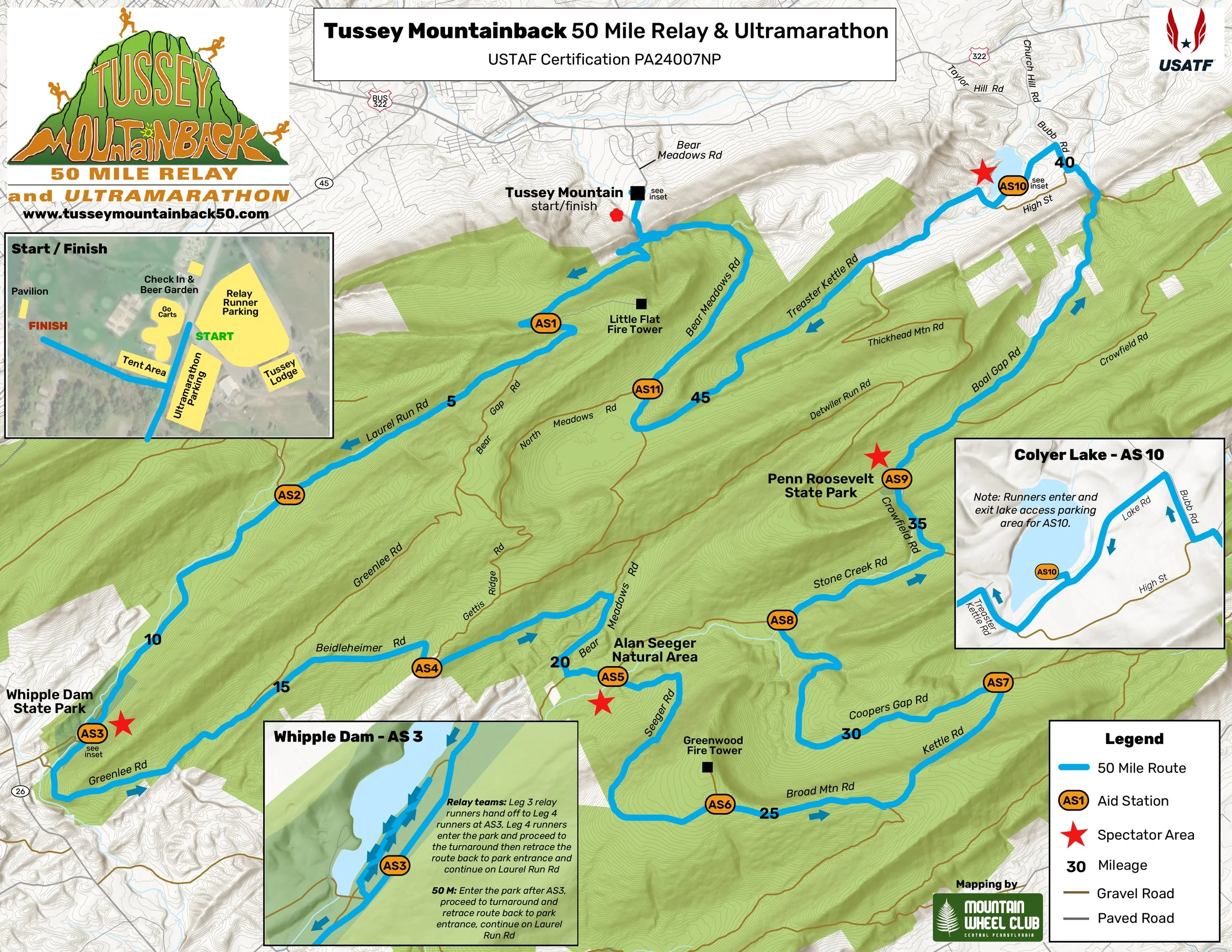
Course map
(Click map to enlarge)
map Overview
Here you'll find the detailed course map for the Tussey Mountainback 50 Mile Ultramarathon. This map provides a comprehensive view of the entire single-loop course, including all critical details necessary for your race planning and preparation.
Key Features of the Course Map:
- Route Outline: The map clearly delineates the entire 50-mile loop, showcasing the starting point at Tussey Mountain Ski Area and the journey through Rothrock State Forest.
- Aid Stations: Marked on the map are the locations of aid stations, spaced approximately every 4-6 miles. These stations are essential for hydration, nutrition, and medical support.
Study the course map thoroughly to familiarize yourself with the route, elevation changes, and aid station locations. This preparation will be invaluable as you tackle the challenging and beautiful Tussey Mountainback 50 Mile Ultramarathon.
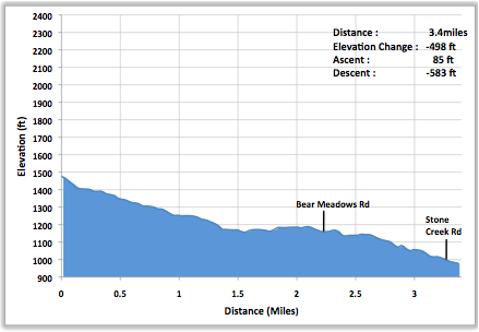
elevation maps Overview
-
The map highlights the total elevation gain and loss of approximately 5,500 feet, giving you a clear understanding of the course's overall difficulty.
-
Major climbs and descents are prominently displayed, allowing you to anticipate the challenging sections of the race and plan your strategy accordingly.
-
The elevation map includes mile markers, correlating with the course map, to help you gauge your progress and manage your energy levels effectively.
-
Aid stations are indicated along the elevation profile, showing you where you can expect to find hydration and nutrition support during both uphill and downhill segments.
-
The highest and lowest points of the course are marked, helping you to mentally prepare for the toughest parts of the race.
-
Clear and frequent course markings help guide runners through the loop, minimizing the risk of getting off course.
leg 1
three bridges, one leg breaker
leg 1 length: 3.2 miles
Difficulty: Moderate
Topography:
Mostly gently climbing, with some steep ascents.
Leg #1 begins on a slight downhill on paved Bear Meadows Road. At bridge #1, the uphill begins. As you pass the stream along the right-hand side, you will traverse bridge #2, continue uphill and turn right onto Laurel Run Road (at 0.7 mi.), crossing bridge #3. At this point the road becomes gravel. Continue climbing to switchback #1, turn and continue up. Switchback #2 occurs at 3.1 miles; only 0.2 miles to Aid Station 1, at the crest of Laurel Run Road and the intersection of Mid-State Trail.
Aid Station 1: At the crest of Laurel Run, at the intersection with the Mid-State Trail. Parking is on the right-hand side beyond the aid station; first vehicle must pull forward to the orange stake, others file in directly behind.
leg 2
down to the swamp
Leg 2 length: 4.0 miles
Difficulty: easy
Topography:
Downhill to level; gravel.
Beginning at the crest of the hill, Leg #2 rolls downhill past the Fleet Foot Hunting Club (0.45 mi.) and Laurel Run Camp (1.1 mi.), both on the right. At the bottom of the hill (1.2 mi.) you will pass Bear Gap Road on the left. Pass Sand Spring Camp and a meandering brook on the right, and go through fern fields as you pass Wildcat Gap Trail. Continue past Bard Gun Club on the left (3.45 mi.) and several cabins to the right and left (3.8 mi.) before coming to the intersection of Laurel Run Road and Pine Swamp Road (on right).
Aid Station 2: At the intersection of Laurel Run and Pine Swamp Road. Parking is on Laurel Run Road on the right-hand side, beyond the aid station.
leg 3
race to the beach
Difficulty: easy
leg 3 length: 3.9 miles
Topography:
Fairly flat; gravel and then finishes
on paved road.
This section of Laurel Run road is slightly winding and mostly flat. Pass through coniferous groves on both sides of the road, Manor Hunting Club on right (2.0 mi.) and cabins on the right and left (2.5 mi), following a meandering brook, continue to Aid Station 3. Turn right at the park sign (3.65m), then another right onto Beach Road to the turnaround point. Reverse back to Laurel Run Road to Aid Station 3.
Aid Station 3: On Laurel Run Road before the entrance to Whipple Dam State Park. Parking is on the right, before the aid station. Restroom facilities are also in park on Beach Drive. There is a spectator area with ample parking.
leg 4
three up, three down
leg 4 length: 5.4 miles
Difficulty: difficult
Topography:
Gently rolling, with several long hills.
Runners continue on Laurel Run Road from the transition zone, then turn left onto Greenlee Road (1.25 mi.), entering a section of rolling hills on packed and loose gravel. At 3.8 miles, bear right onto Beidelheimer Road, ascending a mile-long hill and continuing on gently rolling hills up to the transition zone of Beidelheimer and Gettis Ridge roads.
Aid Station 4: At intersection of Beidelheimer Road and Gettis Ridge Road. Parking is on the right side, beyond the aid station.
leg 5
leg 5 length: 3.4 miles
The Breeze
Difficulty: easy
Topography:
Downhill/flat.
Leg #5 starts off on mostly shaded loose and packed gravel, past vistas on the right, passing by Gettis Ridge Camp on the right, meeting up with Bear Meadows Road (2.2 mi.). Turn right on Bear Meadows Road and continue for about a mile, making a left onto paved Stone Creek Road (3.35 mi.). Just ahead is the Alan Seeger Picnic Area. Bear left into the parking lot, where Aid Station 5 awaits.
Note: At the intersection with Bear Meadows Road, the 50 km racers will turn left and the 50 mile racers will turn right. This is the only point at which it is physically possible to bail out of the 50M and return to the start line. However, the aid station is only one more mile and ill runners should go there for help.
Aid Station 5: Alan Seeger Picnic Area. Parking is in the Alan Seeger parking lot, beyond the aid station. Vehicles should pull in and park as far from the road as possible.
leg 6
stairway to the stars
leg 6 length: 4.1 miles
Difficulty: most difficult
Topography:
Flat for under half a mile, then one
serious, 3+ mile climb.
Leg #6 starts by heading left out of the lot onto paved Stone Creek Road, in a short time (0.4 mi., at bridge) the course reaches Alan Seeger Natural Area on the right and turns right onto Seeger Road. Enjoy the beautiful pine flats and cool air because the next 3.7 miles are a steep and nearly continuous climb to the gated road to the Greenwood fire tower on the left.
Aid Station 6: Gated road to the Greenwood fire tower. Parking is on the right-hand side, beyond the aid station.
leg 7
merrily we roll along
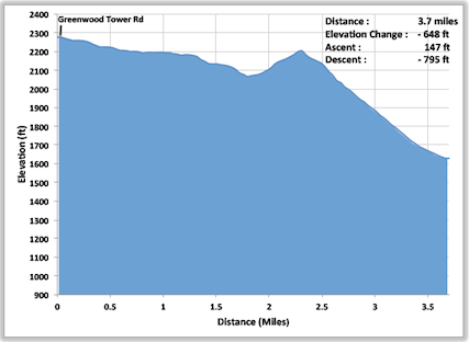
leg 7 length: 3.7 miles
Difficulty: easy
Topography:
Rolling, then a mildly challenging climb, followed by a steep downhill.
Moving out of Greenwood fire tower area, there is a beautiful vista to the left at 1.1 miles. Another 0.7 miles later, turn left onto Kettle Road. Over the next 1.1 miles, the road will first slope downward and then up to a ridge. The last 0.8 miles is a steep downhill to the Aid Station.
Aid Station 7: Intersection of Kettle Road and Cooper’s Gap Road. Parking is on the left side, beyond the aid station.
leg 8
rock on down
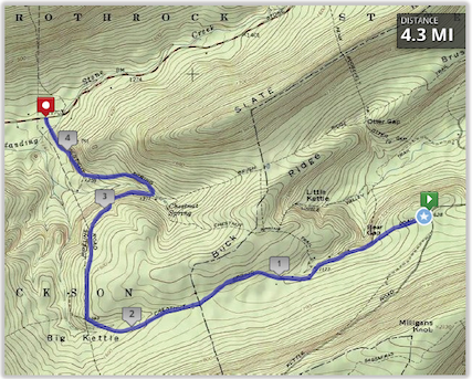
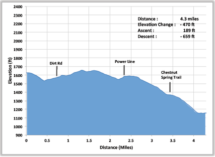
leg 8 length: 4.3 miles
Difficulty: easy
Topography:
Some flat, then gently downhill.
Heading left on Cooper’s Gap Road, the course winds downhill. After the road takes a sharp right turn, it parallels the gas line cut, which can be seen on the left during the descent. Continue to the tee into Stone Creek Road.
Aid Station 8: Intersection of Cooper’s Gap Road and Stone Creek Road. Parking is on the left side.
leg 9
made in the shade
leg 9 length: 2.9 miles
Difficulty: moderate
Topography:
Gently rolling with some moderate climbs.
Heading right on Stone Creek Road, in a short time the course comes to a fork (2.0 mi.), turning left and heading toward Penn Roosevelt State Park. After a slight uphill, the road turns downhill and passes a pleasant vista on the left, then heads past the first entrance into the camping area, at that point bear left and cross a bridge and a babbling brook. In no time the course arrives at the central picnic area and Transition Zone #9, where a picturesque mountain pond and picnic tables create a serene scene.
Aid Station 9: Penn Roosevelt State Park. Parking is on the right-hand side, beyond the Aid Station. Rest rooms available.
leg 10
stream of consciousness
leg 10 length: 5.5 miles
Difficulty: moderate
Topography:
Begins uphill, then gently rolling and downhill.
After moving out of Penn Roosevelt State Park, the course climbs for the first 0.9 mile; once again crossing the Mid-State Trail (0.1 mi.), passing by Rock Oak Camp (0.5 mi.), and forking to the left at 1.0 mile onto Boal Gap Road. Pavement begins at 4.3 miles, then the course takes a left onto Polecat Road (4.4 mi.) then a quick right onto Bubb Road (4.5 mi.). Passing high meadows, glimpses of the lake and the mountains beyond come into view. Make a left onto Lake Road, then finish with a gentle descent toward Colyer Lake. You will turn right into the Colyer Lake parking lot. The aid station is at the far left end of the parking lot.
Aid Station 10: Colyer Lake, occurs at the Colyer Lake parking lot on Lake Road.
leg 11
are we there yet?
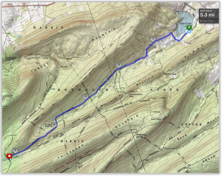
leg 11 length: 5.3 miles
Difficulty: difficult
Topography:
Flat, gently rolling to more serious ups and downs.
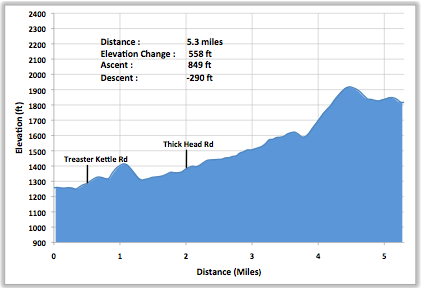
Head out of the lot and make a right on Lake Road. Bear right at intersection with High Street, staying on Lake Road, cross a bridge, go 0.4 mile uphill, and make a left onto paved Treaster Kettle Road. Once on Treaster Kettle, the road alternates between pavement and gravel for a short distance, eventually maintaining a gravel surface. At 1.3 miles bear right, pass Thickhead Road intersection on the left (2.0 mi.), continue through several long climbs and descents, passing Mexico Gun Club (3.1 mi.), until the intersection with Bear Meadows Road (5.2 mi.). Turn right onto Bear Meadows Road and continue for 0.5 mi. to aid station 11.
Aid Station 11: Aid Station 11 is at the intersection of Bear Meadows Road and North Meadows Road, at the yellow gate. Parking is both at and before the aid station, on the right and left. Do not block the gate in any way.
leg 12
trucks use lower gear!
leg 12 length: 4.2 miles
Difficulty: easy
Topography:
Mostly downhill, winding.
This final, mostly paved and shaded leg continues on Bear Meadows Road, from North Meadows Road, turning to pavement at 1.0 miles (time for your overdrive gears), and continuing down a fairly steep downgrade, passing Laurel Run Road on the left at 3.1 miles, and winding over bridges 1 (3.2 mi.) and 2 (3.3 mi.). The final quarter-mile is a fairly flat sprint out of the trees, making a left toward the pavilion, and to the finish line, at Tussey Mountain Ski Resort.
Finish Line: At the pavilion beside the lake.
